The partnering approach to reaching common goals of the Corps' environmental mission is evident in recent and ongoing research activities in north central Texas. The construction of wetlands at Ray Roberts Lake has provided a unique situation for the Corps, various state and federal resource agencies, and an institute of higher learning to put forth a concerted effort and take advantage of new and exciting opportunities. These studies will help expand our understanding of wetland dynamics, the structure and function of constructed wetlands and allow us to fine tune our techniques for wetland construction and restoration.
Ray Roberts Lake, located in Denton, Cooke and Grayson counties in north central Texas, is on the Elm Fork of the Trinity River approximately 40 miles north of the Dallas-Fort Worth Metroplex. Constructed by the Corps' Fort Worth District, Ray Roberts was completed in June 1987 and is one of eight Corps reservoirs in the Trinity River Basin. The total area of the watershed above Ray Roberts Dam is 692 square miles and the conservation and flood control pools contain 29,350 and 36,900 acres, respectively. The authorized purposes of the reservoir are flood control, water supply, and recreation.
In an effort to further address the environmental concerns in all phases of project planning, design, construction, and operation and maintenance, the Fort Worth District has conducted pre-impoundment and two-year post-impoundment environmental studies at Ray Roberts. The district is currently conducting a five-year, post-impoundment study which includes environmental studies of constructed wetland cells that were completed in 1992. The purpose of the wetland studies, which include monitoring of vegetation and wildlife utilization, is to improve our understanding of constructed wetlands and provide baseline data for future studies.
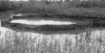
A series of six wetland cells have been constructed along Range Creek, a tributary of the Elm Fork Trinity River. The complex consists of approximately 170 acres of wetlands that are divided by low earthen levees with water control structures to allow gravity flow of water from one cell to the next. Water is supplied to the wetlands by flooding of Range Creek, rainfall, and local drainage. Since there is no mechanism to pump water into the wetland cells, the water regime of the wetland complex will vary from year to year and the individual cells will vary in any given year. The system is operated by the Texas Parks and Wildlife Department for the purpose of wildlife management, with emphasis on providing beneficial conditions for waterfowl.
The constructed wetland system is an extraordinary example of an outdoor laboratory that offers excellent research opportunities. In addition to the current wetland environmental studies, sedimentation and water quality studies are being conducted by the Waterways Experiment Station in conjunction with the U.S. Geological Survey and the Texas Parks and Wildlife Department. Also, the Lewisville Aquatic Ecosystem Research Facility, a satellite station of WES located at Lewisville Lake, conducted experimental plantings of wetland and aquatic plants, which were funded by a grant from the Environmental Protection Agency.
The current environmental study of the constructed wetlands, which is funded largely by WES through the Wetlands Research Program, focuses on monitoring wetland vegetation and wildlife utilization of the area. The Institute of Applied Sciences at the University of North Texas is instrumental in this research effort. In fact, two graduate students are basing their theses on research that they are contributing to the study.
Research activities began in the fall of 1993 and continued through 1994. The final report will be submitted as an appendix to the five-year post-impoundment study that will be completed in September 1995.
The vegetation component of the study serves a dual purpose:
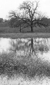
Preliminary finding show that most of the aquatic and wetland vegetation plots have evidence of survival and expansion. Permanent transects were established in all of the wetland cells and vegetation is monitored using the point-intercept method.
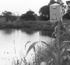
Wildlife at the wetland complex is monitored quarterly. Birds are observed from blinds while mammals are monitored by visual observations and track identification. Results indicate that the wetland complex is being heavily utilized by waterfowl and shorebirds. The wildlife monitoring provides data on the utilization of newly constructed wetlands which can be used as a baseline for future studies of the aging wetland system.
Research projects made possible by the cooperative efforts displayed at Ray Roberts wetlands contribute to our knowledge of the intricate relationship of wetlands and the plants and animals that live there. Future studies will build on that knowledge to increase our understanding of how to create and restore viable, functioning wetland systems.
(Reprinted from the Fall 1994 issue of Nexus, a professional publication of the U.S. Army Corps of Engineers, Fort Worth District. Point of contact for additional information is Mary Flores, (817) 334-3246).