 |
|
 |
|
 |
|
|
|
|
 |
|
 |
Projects
Regional supplements to the Corps of Engineers Wetland Delineation Manual
Wetland delineation remains fundamental to Corps of Engineers and Environmental
Protection Agency regulatory responsibilities under Federal regulations (33 CFR
320-330), Section 404 of the Clean Water Act (CWA). Wetland delineation consists
of standardized procedures for identification of wetlands and their boundaries to
define the limits of Federal jurisdiction under the CWA. The Corps of Engineers
Wetlands Delineation Manual historically contained indicators and methodologies
for delineating wetlands. As scientists continually expand the pool of knowledge
concerning wetlands, regulatory manuals should incorporate new methods, indicators,
and approaches. As a result the WRTC implemented the development of ten
regional supplements to the Corps of Engineers Wetlands Delineation Manual
providing a vehicle for the inclusion of new and improved technical guidance for
wetland delineation. The regional supplements account for provincial differences
in climate, geology, soils, hydrology, plant and animal communities, and other factors
impact the identification and functioning of wetlands. The regional supplements
include regionalized lists of field indicators of wetland vegetation, hydrology,
and hydric soils and expand procedures for problematic and difficult wetland delineations.
Wetland and Stream Assessment
A number of federal laws, policies, and regulations require that resource managers
assess (i.e., evaluate the nature) of ecological conditions and funcitons within
wetland and stream environments. The WRTC supports a variety of wetland and stream
assessment approaches including the
Hydrogeomorphic Approach (HGM Approach),
a method capable of assessing the functional condition of an ecosystem. The approaches
designed and implemented through the WRTC utilize ecosystem classification systems based
on geomorphic position and hydrologic characteristics to group ecosystems into different
classes (e.g., depressional, riverine, fringe wetland). Additionally, the ecosystem
assessment tools developed by WRTC utilize field data in support of assessment scaling,
variable selection, and application. Wetland and stream assessments are commonly used to
determine current ecosystem condition, mitigation ratios, post-project impacts, and restoration
success. WRTC staff also provide research in support of validating existing assessment approaches
through testing assessment outcome accuracy using comparisons with field or laboratory
measures. Validation measures recently examined assessment approaches in the lower
Mississippi River valley and in the Appalachian region.
Beneficial Use of Dredge Materials
The WRTC supports wetland expansion and restoration projects through the assessment
and management of wetlands created using dredge materials. These activities include
monitoring of plant assemblages, soil deposition and horizon development, and faunal
surveys used to determine the quality and success of dredge material wetland creation
and restoration projects.
Integrated Ecological Modeling
The Integrated Ecological Modeling team made up of WRTC personnel specializes in
developing modeling approaches used to answer complex environmental problems across
various scales. The team focuses on understanding how critical species, including
threatened and endangered species, invasive species, and species of interest (such
as commercial fisheries) are impacted by changing climates, environments, and/or
management actions. Ecosystems are inherently complex and consist of myriad interacting
factors. Ecological modeling provides natural resource managers, planners, and environmental
scientists with tools necessary to inform environmental decision-making practices.
The team works with stakeholders to quickly develop scientifically-defensible approaches
for informing any environmental decision making practices.
Wetlands and Watersheds - MAWI
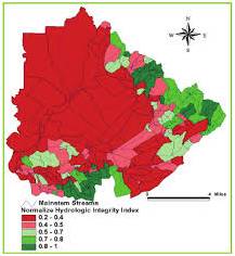
The Multi-Scale Assessment of Watershed Integrity (MAWI) approach assesses the integrity
of riparian ecosystems and their adjacent local drainages within a watershed using
a suite of indicators representing both large- and small-scale attributes and processes
that influence ecosystem integrity. The hydrologic, water quality, and habitat integrity
indices resulting from the baseline assessment provide a ranking of riparian ecosystem
integrity within a watershed that can be easily manipulated and displayed in a GIS.
The MAWI approach provides a GIS-based decision support system that integrates information
and data at varying scales to produce spatially-explicit assessments on defined
management concerns within a watershed. Recent applications of the approach in the
western United States include the assessment of riverine ecosystem and watershed
integrity. Assessment results are employed in a variety of ways, including baseline
assessment and alternatives analysis. Revised assessments can be produced as updated
or higher quality data becomes available. Ongoing efforts continue developing the
MAWI approach for other regions.
Identification of altered and problematic wetlands
WRTC staff frequently aid USACE Districts, the EPA, and other agencies in the identification
and delineation of altered and problematic wetlands throughout the United States.
Altered wetlands include areas subject to fill placement, drainage, agriculture/silviculture,
and other human activities resulting in disturbances that make wetland identification
difficult. Recent WRTC projects examined altered wetlands exposed to fill materials
within floodplains and areas subjected to long term hydrologic modification (e.g.,
drainage, irrigation). Problematic wetlands include areas that are hard to identify
due to a natural feature affecting the presence of indicators of wetland hydrology,
hydric soils, or hydrophytic plants. WRTC staff recently examined problematic wetlands
throughout the upper Midwest exhibiting red parent materials, marl soils, and high
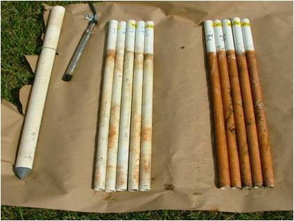
chroma sandy soils. These projects often utilize technologies including Indicator
of Reduction in Soil (IRIS) tubes, groundwater monitoring and modeling, alpha-alpha
dipyridyl dye and the application of the Corps of Engineers Technical Standard for
Water-Table Monitoring of Potential Wetland Sites and the Technical Standard for
Hydric Soils. Study results often lead to development of new guidance for wetland
delineators in the affected region.
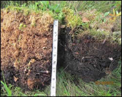
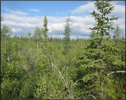
Investigation of permafrost hydric soil vegetation characteristics in Alaska
As part of an effort to improve permafrost mapping capabilities and promote installation
infrastructure longevity, WRTC staff examined permafrost soils across wetland transects
located near Fairbanks, AK. Measurements included hydric soil descriptions, determinations
of soil moisture, depth to permafrost and carbon and nitrogen content. Additionally,
inventories of floral communities provided data on changes in vegetative cover within
areas exhibiting polygonal/patterned ground features commonly associated with permafrost.
The collected data allowed for the establishment of relationships between soil parameters
and plant cover types. Future work will incorporate measures of plant photosynthesis,
remote sensing data, subsurface resistivity, and ground penetrating radar.