Northern Rocky Mountain gravel bed alluvial floodplains
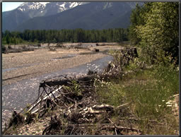 This Regional Guidebook was developed to assess the ecological functions of wetlands of gravel-bed,
alluvial riverine floodplains of the northern Rocky Mountains. Throughout the Rocky Mountains of Montana,
Wyoming, Idaho, and northeastern Washington, the rivers are largely characterized by a series of
attributes that greatly affect their ecological structure and function.
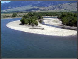
This Regional Guidebook was developed to assess the ecological functions of wetlands of gravel-bed,
alluvial riverine floodplains of the northern Rocky Mountains. Throughout the Rocky Mountains of Montana,
Wyoming, Idaho, and northeastern Washington, the rivers are largely characterized by a series of
attributes that greatly affect their ecological structure and function.
The Rocky Mountains of northwestern Montana are formed of sedimentary bedrock from the late Paleocene to
the Proterozoic period that have been affected by low-grade metamorphosis. These mountain ranges are part
of the Rocky Mountain Belt Supergroup and consist of argillites, siltites, and carbonates with a maximum
stratigraphic thickness of 5,200 m (Whipple et al. 1984). In contrast, the mountains of Idaho and northern
Wyoming, including the geographic area of the Bitterroot Mountains and the Sawtooth Mountains of eastern and
central Idaho, which comprise the Idaho Batholith, are primarily of granitic origin. Throughout the northern
Rocky Mountains, glacial ice has
 profoundly affected valley geomorphology. Colluvium and glacial till mantle the valleys. During the end
of the last major glaciation of the Pleistocene era, about 20,000 years ago, the valleys of western
Montana and northern Idaho and Washington were covered by the continental cordilleran ice sheet. The main
glacial advance flowed from the cordilleran ice sheet down the Rocky Mountain Trench in Montana and the
Purcell Trench in Idaho and along the Rocky Mountain front in the Great Plains of Montana. Smaller valley
glaciers flowed from the various mountain ranges (e.g., Livingston, Whitefish, Bitterroot, Absoroka, Garnet)
to merge along valley floors and form trunk glaciers as much as 1,000 m thick. Alluvial valley segments of
tributary drainages formed with faulting and local accumulations of valley fill from alluvial and glacial
sources. Ice dams in the Purcell Trench in northern Idaho resulted in the periodic filling of Lake Missoula
and catastrophic flooding as they broke, sending water across eastern Washington.
profoundly affected valley geomorphology. Colluvium and glacial till mantle the valleys. During the end
of the last major glaciation of the Pleistocene era, about 20,000 years ago, the valleys of western
Montana and northern Idaho and Washington were covered by the continental cordilleran ice sheet. The main
glacial advance flowed from the cordilleran ice sheet down the Rocky Mountain Trench in Montana and the
Purcell Trench in Idaho and along the Rocky Mountain front in the Great Plains of Montana. Smaller valley
glaciers flowed from the various mountain ranges (e.g., Livingston, Whitefish, Bitterroot, Absoroka, Garnet)
to merge along valley floors and form trunk glaciers as much as 1,000 m thick. Alluvial valley segments of
tributary drainages formed with faulting and local accumulations of valley fill from alluvial and glacial
sources. Ice dams in the Purcell Trench in northern Idaho resulted in the periodic filling of Lake Missoula
and catastrophic flooding as they broke, sending water across eastern Washington.
Guidebook
Hauer, F.R., B.J. Cook, M.C. Gilbert, E.J. Clairain, and R.D. Smith. (2002). "A Regional Guidebook for Applying the
Hydrogeomorphic Approach to Assessing Wetland Functions of Riverine Floodplains in the Northern Rocky Mountains,"
ERDC/EL TR-02-21,
U.S. Army Engineer Research and Development Center, Vicksburg, MS.
(FCI Calculator)

Back to HGM Approach
Web Date: October 1997
Updated: April 2008
|